In this page you will find some GIS
datas of Thailand:
Digital elevation models, from SRTM-4:
- DEMs for whole Thailand (300 m resolution)
- DEMs for whole Thailand (400 m resolution)
- DEMs for whole Thailand (500 m resolution)
Meteorologial Data, 1981-2001, by month, by station or district:
- Rainfall (mm)
- Minimum Temperature (C°, extreme)
- Maximum Temperature (C°, extreme)
- Mean Temperature (C°)
- Minimum Relative Humidity (%, mean)
- Maximum Relative Humidity (%, mean)
- Mean Relative Humidity (%)
Land use and Land cover, 2000, from Royal Forest Department, based on Landsat 5 remote sensing cover on Thailand
- Land use
Streams, from topographic maps and PGIS data set
- Streams
All datas are free for scientific
use. Please indicate the source and credit (Marc Souris, IRD) when you
use it.
All datas are SAVANE and ArcView compatible. All Shapefile vector datas
are in geographic decimal degrees coordinate (long, lat), in INDIAN
1954 Datum (Ellipsoid is Everest Indian).
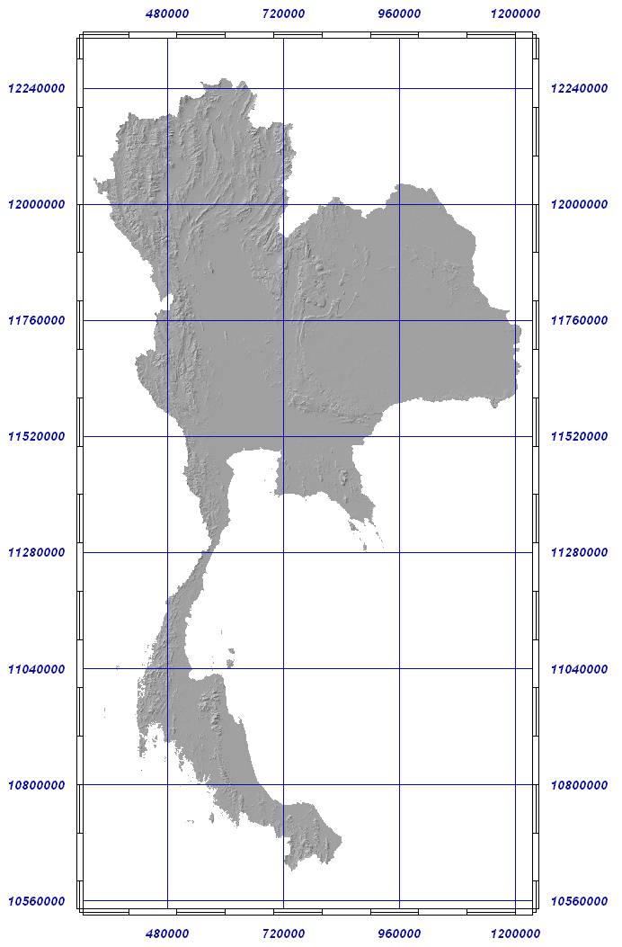
Thailand
DEM from SRTM-4 re-interpoled at 300 m resolution
All
DEMs were generated from SRTM-4 90m resolution, using the SavGIS software.
Datum is INDIAN 1954 for Thailand. Projection is UTM zone 47. Elevation
is in meters above see level (SRTM-4). The files are in ASCII raster format
(compatible ArcGIS). All files are zipped.
*for each file, the Y Coordinate of lower point is UTM+10000000 if
in north hemisphere. You can edit the file to remove this offset
- Click on the map to download the area you are interested in (each square
is a downloadable area). Each area is 800*800 pixels whith a resolution
of 300 m per pixel.
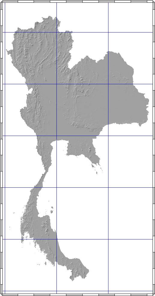
Thailand
DEM from SRTM re-interpoled at 400 m resolution
All
DEMs were generated from SRTM-4 90m resolution, using the SavGIS software.
Datum is INDIAN 1954 for Thailand. Projection is UTM zone 47. Elevation
is in meters above see level. The files are in ASCII raster format (compatible
ArcGIS). All files are zipped.
*for each file, the Y Coordinate of lower point is
UTM+10000000 if in north hemisphere. You can edit the file to remove this
offset
- Click on the map to download the area you are interested in (each square
is a downloadable area). Each area is 800*800 pixels whith a resolution
of 400 m per pixel.
Thailand
DEM from from SRTM re-interpoled at 500 m resolution
All
DEMs were generated from SRTM using the SavGIS software.
Datum is INDIAN 1954 for Thailand. Projection is UTM zone 47. Elevation
is in meters above see level. The files are in ASCII raster format (compatible
ArcGIS). All files are zipped.
*for
each file, the Y Coordinate of lower point is UTM+10000000
if in
north hemisphere. You can edit the file to remove
this offset
- Click on the map to download the area you are interested in (each square
is a downloadable area). Each area is 800*800 pixels whith a resolution
of 500 m per pixel.
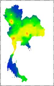
This information was proceded from data of Ministry of Transportation of Thailand. The red of meteorological stations cover the whole country (84 principal stations for temperature, relative humidity, pressure, ect., and 996 secondary stations for rainfall).
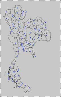
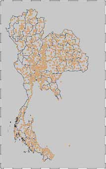
Principal and secondary meteorological stations in Thailand
- Temperature,
by month, from 1981 to 2001, in C° (Celsius)
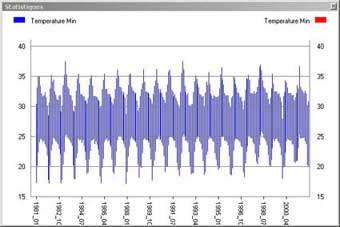
Mean of extreme temperature, 20 years in Thailand
By stations
For each station, the values represent for each month the extreme minimum of the month (Temperature Min), the extreme maximum temperature of the month (Temperature Max), and the mean temperature of the month (average of daily means). In Shapefile format, download Temperature.zip (96 Kb, compressed).
By sub-districts (Amphoe, 926 zones in 2000)
The value is calculated for each district by interpolation (to create a digital model) and geoagregation from the station data. The interpolation process is for each point a barycentric mean (inverse distance) on all neighbouring stations (maximum distance200 km), with a linear function (-0.006 °C/m) for the elevation constraint. The geoagregation calculate for each zone the extreme value (extreme minimum, extreme maximum) from the corresponding interpolated dataset.
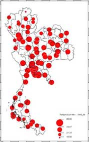

Initial meteo stations, interpolation, geoaggregation process (SavGIS GIS)
In Shapefile format, download AmphoeTempShapefile.zip (4.2 Mb, compressed). This compressed file containt two Shapefile, one for Maximum Temperature, one for Minimum Temperature.
In Exel format, without co-ordinates, download AmphoeTempExel.zip (3.8 Mb, compressed).
- Relative Humidity,
by month, from 1981 to 2001 (in percentage)
 Relative
Humidity is fully time correlated with Rainfall !The values represent for each
month the extreme minimum of the month (RHumidity Min), the extreme maximum
of the month (RHumidity Max), and the mean relative humidity of the month
(average of daily means). All values are in percentage.
Relative
Humidity is fully time correlated with Rainfall !The values represent for each
month the extreme minimum of the month (RHumidity Min), the extreme maximum
of the month (RHumidity Max), and the mean relative humidity of the month
(average of daily means). All values are in percentage.
In Shapefile format, download RHumidity.zip (69 Kb, compressed)
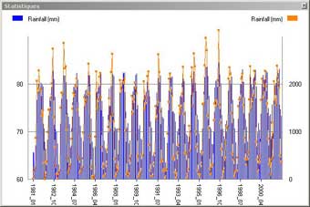
- Rainfall, by month, from 1981 to 2001 (in mm)
By stations
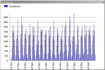
The values represent for each station (1080 stations for Rainfall) and for each month the total of precipitations, in mm. A value of 0.1 represent a trace of rainfall. All values are in mm.
In Shapefile format, download Rainfall.zip (487 Kb, compressed)
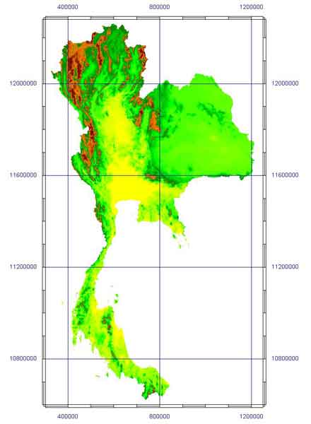
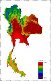
Thailand Land use and forest cover
Year 2000
This
detailled information is from Royal Forest Department of Thailand (National
Park Wildlife & Vegetation Conservation Department), and represent
land use oriented to forest cover. The file cover the whole country and
is made from Landsat TM satellite images (30 m resolution), with detailed
type of forest or land use.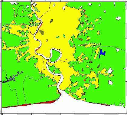
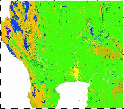
Land use in Central Thailand and Bangkok area
In Shapefile format, download Forest2000.zip (41.4 Mb, compressed). Interpretation code is in the file ForestCodes.xls.
Thailand rivers and streams
Digitized from topographical maps of Thailand and PSIG data set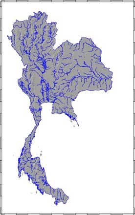
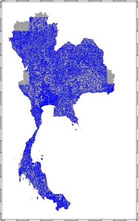
Rivers (PSIG) and streams (TD)
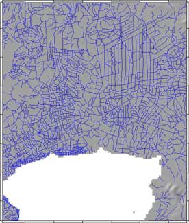
Detail of streams in Bangkok and central Thailand (TD)
- In Shapefile format, download Streams.zip (6 Mb, compressed).
![]()
![]()
![]()